A site on the sandy terraces near Cap-de-la-Madeleine behaves nothing like one down in the lower city near the Saint-Maurice floodplain. The difference comes down to the Champlain Sea clay and its variable thickness across Trois-Rivières—sometimes 10 meters, sometimes over 40. We rely on vertical electrical sounding to map those transitions without punching a hole in the ground. A test pit can confirm the first two meters, but when we need to know what sits at 15 or 30 meters below the surface, resistivity sounding gives us a continuous profile. In Trois-Rivières, where the marine clay is saline enough to drop apparent resistivity below 10 ohm-m, the VES method is particularly diagnostic. It lets us separate the soft clay from the underlying till and the fractured shale of the Lorraine Group that makes up the bedrock across the Trois-Rivières area. Our field crews run Schlumberger arrays with expanding electrode spacing, then invert the data to produce a layered resistivity model tied to the local geology.
Marine clay in Trois-Rivières drops below 10 ohm-m. That low resistivity is a signature—it tells us exactly where the Champlain Sea deposit thickens.
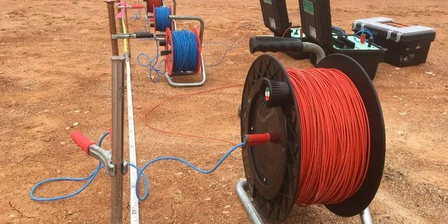
Methodology applied in Trois-Rivieres
Critical ground factors in Trois-Rivieres
In Trois-Rivières, we regularly see sites where the marine clay pinches out against a buried bedrock ridge, and the resistivity profile changes completely within a 50-meter lateral shift. If the investigation skips VES and relies only on isolated boreholes, the contractor hits rock where the design assumed soil—and the excavation plan falls apart. The biggest operational risk is poor electrode coupling in dry surface sand; we solve it by wetting the electrodes with a bentonite slurry and checking contact resistance before every measurement cycle. Another risk specific to the Mauricie region is cultural noise: buried power lines along Boulevard des Forges and stray currents from the industrial sector near the port can distort the voltage reading. Our resistivity meter runs at 128 Hz to reject 60 Hz powerline interference, and we always stack multiple readings per spacing to drive down the standard error below 2%.
Our services
Our electrical resistivity services in Trois-Rivières cover the full workflow from field acquisition to interpreted geotechnical sections.
1D Vertical Electrical Sounding (Schlumberger)
Single-station resistivity-depth profiling to map clay thickness, depth to bedrock, and groundwater interface. Typically 8–12 soundings across a Trois-Rivières site.
2D Resistivity Imaging / ERT
Multi-electrode profiles with Wenner-Schlumberger arrays for continuous cross-sections. Used along proposed pipeline routes and embankment alignments.
Induced Polarization (IP)
Time-domain chargeability measurements combined with resistivity. Useful for distinguishing clay-rich zones from clean sand aquifers in the Saint-Maurice delta.
Data Integration & Geotechnical Correlation
We calibrate resistivity layers against borehole logs and Atterberg limits, producing a unified ground model for foundation design.
Frequently asked questions
How much does a VES survey cost in Trois-Rivières?
A single VES sounding with Schlumberger array typically runs from CA$850 to CA$1,460 depending on the maximum AB/2 spread and site access. A full site survey with 8–10 soundings and a correlated geotechnical report is priced per project; we provide a fixed quote after reviewing the site plan and local geology.
What depth can electrical resistivity reach in the Trois-Rivières area?
With a Schlumberger array, the effective depth of investigation is roughly AB/2 divided by 3. In Trois-Rivières we commonly deploy AB/2 up to 150 meters, giving a practical investigation depth of about 50 meters. The actual penetration depends on the resistivity contrast: the conductive marine clay attenuates the signal, but the resistive bedrock at depth still produces a clear response.
Which resistivity method works best for mapping Champlain Sea clay?
Vertical Electrical Sounding with the Schlumberger array is the standard for resolving clay thickness in Trois-Rivières. The clay’s low resistivity (5–15 ohm-m) creates a strong contrast against the underlying till (30–60 ohm-m) and shale bedrock (80–150 ohm-m). For lateral variations, we supplement with 2D electrical resistivity tomography (ERT).
How long does a VES survey take on site?
A single VES station takes about 45–60 minutes including electrode layout, contact resistance checks, and data stacking. A 10-sounding survey across a typical Trois-Rivières commercial lot is usually completed in one field day. Data processing and inversion are done the same day; the interpreted report follows within 3–5 working days.