You know the sound a Cat 308 excavator makes when its bucket hits a dense till lens at two metres depth — the whole boom shudders. That is where a test pit earns its value. In Trois-Rivières we open trenches typically 2.5 to 4 metres deep, directly exposing the stratigraphy so the geotechnical engineer can walk into the excavation and log every change: oxidized crust, grey silty clay, transition to water-bearing sand. No split spoon, no thin‑wall tube can give you that spatial continuity. For projects near the Saint‑Maurice River terraces, where the younger alluvium overlies Champlain Sea deposits, a single pit can answer what three SPT borings would only hint at. We also run in‑situ density checks with the sand cone density test right at the excavation floor, so the compaction data comes from the same unit the footing will bear on.
A well‑logged test pit in the Saint‑Maurice River plain often reveals a geological story that no borehole log can capture.
Methodology applied in Trois-Rivieres
Critical ground factors in Trois-Rivieres
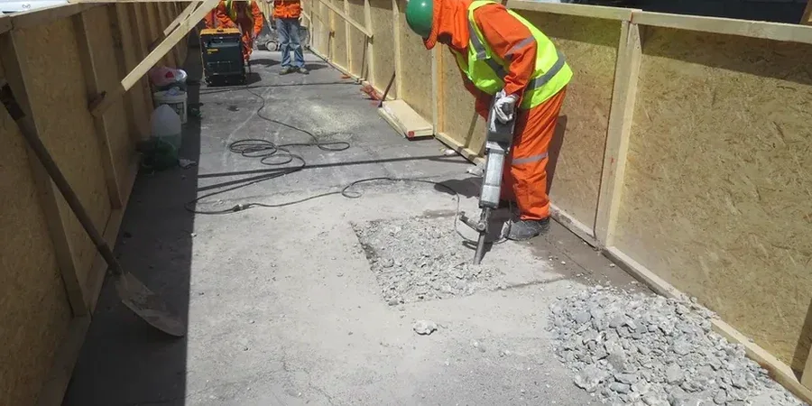
Trois‑Rivières sits between two rivers, and the groundwater table is rarely deeper than 1.8 m in spring. Most test pits in the city hit water before reaching the design depth. That means we cannot just dig and leave the sides unsupported: a sudden inflow of water‑charged sand can trigger a slope failure inside the pit, and the last thing any site superintendent wants is a trench collapse next to an existing structure. Our protocol in the urban core — from the Cap‑de‑la‑Madeleine sector down to the historic district — includes a trench box or sloped benching as soon as the cut exceeds 1.2 m, plus a sump pump running continuously when the fine sand of the Saint‑Maurice delta starts weeping. If the stratigraphy shows layered soft clay over dense till, we coordinate with the slope stability analysis early so the pit data feeds directly into the cut‑and‑cover design parameters.
Our services
Every test pit we open in the Mauricie region gets logged by a geotechnical engineer who knows the local Quaternary map. Once the pit is backfilled and compacted, the value lives in the report — and in the lab data that backs it up.
Stratigraphic logging and block sampling
Direct visual identification of stratigraphic units, measurement of crust thickness, and extraction of undisturbed block samples from the Champlain Sea clay for advanced laboratory programmes including consolidation and triaxial testing.
In‑situ density and compaction verification
Sand cone testing on the excavation floor to verify bearing stratum density, and post‑backfill compaction control using nuclear gauge or sand cone methods per ASTM D1556, with results referenced to the Proctor curve obtained from pit material.
Frequently asked questions
How much does an exploratory test pit cost in Trois‑Rivières?
For a standard test pit 2.5 to 3.5 m deep in the Trois‑Rivières area, including machine time, traffic control, logging by a geotechnical engineer, one in‑situ density test and a concise report, the budget typically falls between CA$780 and CA$1,110. The final figure depends on access constraints, groundwater handling and whether a trench box is required.
What safety measures do you follow when digging test pits in the city?
We follow the CNESST Safety Code for Excavation (S‑2.1, r. 13). For any pit deeper than 1.2 m we use sloped benching or an engineered trench box. A spotter remains at surface level throughout the operation, and the pit is barricaded and signed at the end of each shift.
Can you dig a test pit in winter when the ground is frozen in Trois‑Rivières?
Yes, but it changes the approach. From late December through March the frozen crust can be 1.2 to 1.5 m thick in the Mauricie region. We use a hydraulic hammer on the excavator to break through the frost layer, then proceed with standard digging. The pit face thaws quickly enough for logging, though we schedule block sampling for days when the air temperature stays above −10 °C so the wax seal cures properly.